The storms hit from the southeast. At high tide, the sea smashed its way through Torcross in Devon. Residents feared for their lives as they sheltered in their rattling, inundated homes.
It was 1859, and the community at Torcross wondered if their village would survive the night.
Over 160 years later, in January 2026, three named storms smashed into Torcross again. In response, the Environment Agency announced in mid-May they would spend £19.8 million pounds protecting their homes.
Naturally, defiantly, the villagers want to hold the line against the sea. But even after £20m is spent, can their battle ever be won? After all, there are perhaps thousands of lost settlements just off shores all around the world.
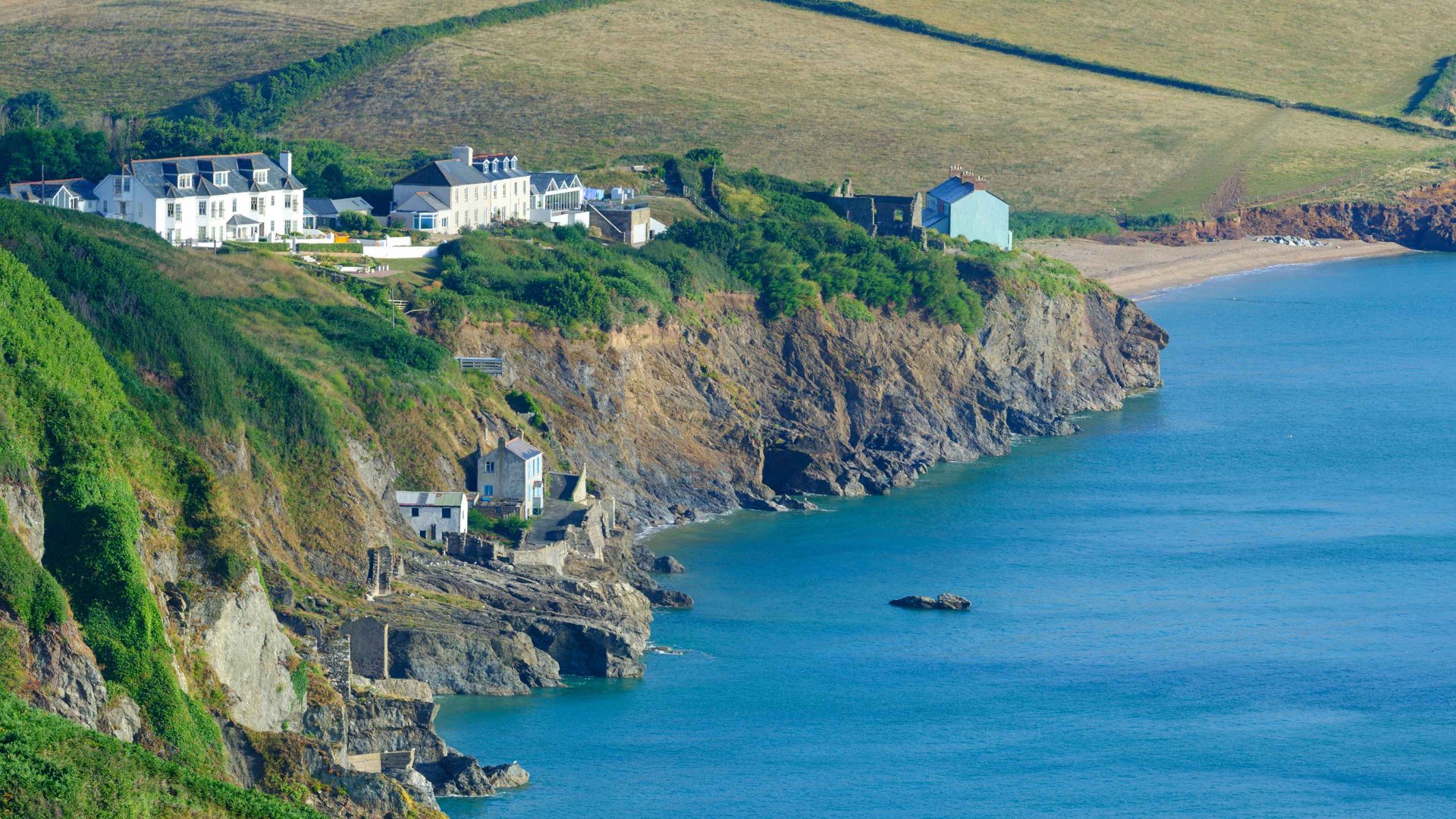
Start Bay is on the south coast of Devon. Its coastline includes Slapton Sands, where the beach rises to a shingle ridge known as the Slapton Line. Beyond the ridge is a freshwater lagoon. Along the ridge, a tarmac road leads – or rather led – from the village of Strete in the north to Torcross in the south.
Storm fronts build in the warm Atlantic before being funnelled up towards the British Isles. Start Bay is on the front line, and Torcross’s beachfront has – or rather had – a defensive seawall.
In 1978, the village was almost destroyed by a storm. In 2001, its road was broken up by the sea.
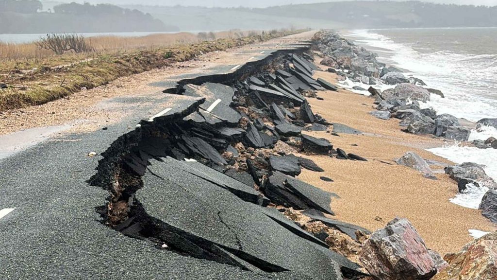
This January, Storm Goretti lowered the beach height by two metres in one night, exposing the seawall’s foundations in front of the village. Then storms Ingrid and Chandra smashed into the buildings, with waves hitting the roofs.
Finally, two unnamed storms hit. With defences ruined, they broke the road up as if it were a slab of dark chocolate.
Although the coast road is gone, Torcross is not cut off. The main road inland towards Kingsbridge remains, and a network of lanes switch back their way eastwards towards Dartmouth. These are old back roads, though, no wider than a horse-drawn cart. In an area dependent on tourism, the reduced access has hit businesses in the village hard.
After the 2001 storm, the local councils, the Environment Agency (EA) and scientific experts formed a local partnership to look at the future of the Slapton Line. Modelling showed that the shingle ridge wants to roll over itself, retreating into the freshwater lagoon. That’s a natural process: trying to stop it would be futile. As we say in the west country, the sea always wins.
The partnership agreed a strategy back in 2001. Hold the line at Torcross, protecting the settlement of around 150 properties until perhaps 2055 when it may have to be abandoned. It’s here that the EA will reinforce the defences with rock armour.
The strategy for the road, however, was to manage its retreat as the ridge shifted until 2025. Then it would be abandoned once triggers, “to be agreed”, were met. This timeframe allowed a couple of decades for the alternative inland route to Dartmouth to be upgraded with more passing points.
But that didn’t happen. Julian Brazil, who became Lib Dem leader of Devon County Council in 2024, has said, “We should have acted sooner. At that stage, it wasn’t really up to me, but it is now.”
Suggested Reading


Caroline Lucas: No10 ignored MI5 and MI6 warnings on climate change
The residents are pushing for the government to commit to repairing the coastal road. Their MP, Caroline Voaden, asked about it at prime minister’s question time, met with transport ministers and has handed in a petition with 39,000 signatories asking for more support.
Gerd Masselink is professor of coastal geomorphology at Plymouth University and has been researching the impact of the sea along Slapton Sands for 20 years. His team have identified a pattern. Southerly storms move hundreds of cubic metres of shingle, stripping away Torcross’s shoreline, then an easterly will send the sea crashing over the exposed defences.
The team’s site-specific records only go back 20 to 40 years, but earlier wind measurements taken along the coast at Plymouth allow the team to extrapolate backwards. And these fit with local history because Torcross is not the first village in the bay to be eaten by the sea.
To the south of Torcross is Hallsands, a fishing village nestled by the cliffs and all but abandoned after a 1917 easterly overwhelmed it. To the north are the remains of Strete Undercliff, a fishing village abandoned in the early 1780s after a series of great storms.
Masselink’s research indicates the move of the shingle is inevitable. When he began research at Torcross 20 years ago, he could step off the beachfront onto the sand. That beach is six metres lower now.
The phrase “coastal erosion” brings to mind houses teetering on the brink as cliffs fall away beneath them. What the villages of Start Bay illustrate is the principle of inundation: the sea devours villages rather than nibbling away at them. The dilemma for the people living there is the same that faces communities worldwide who live precariously close to the changing coasts.
In 2009, a United States government report stated the village of Shaktoolik in Alaska was at “imminent risk” of coastal erosion and flooding. Shaktoolik is a small settlement of just over 200 people living on a spit of gravel and sand in Norton Sound on the Bering Sea. Behind the settlement, the Tagoomenik river flows. The only road access is along the Iditarod dirt trail running along the gravel spit.
Each tropical storm that barrels up from the Pacific, funnelled into the Bering Sea, eats into the spit so the shoreline is rolling back. “We’re almost becoming an island,” Lars Sookiayak, the mayor of Shaktoolik, has warned.
Unlike Torcross, there is no back road. If the trail breaks up, the only way to get in or out of Shaktoolik will be their small dirt airstrip.
Their current location is in fact the third Shaktoolik. It began as a village further up the river, then moved to the mouth of the estuary in 1933. By 1967, storms forced a move to their current position. Most of the residents are Inupiat, the indigenous people of the Bering Straits region. To protect their village from the sea, they built a berm, a form of raised ridge, in 2014. This sea defence is made of gravel, sand and driftwood rather than the concrete and metal of Torcross. It should disrupt the storm waves, robbing them of their destructive power.
But in 2022, a typhoon formed over the hot Pacific and swirled its angry way north. The residents evacuated to the school hall for safety. The storm tore through the berm and smashed into the houses. Unlike Torcross, the residents of Shaktoolik are ready to retreat. After all, they have moved before.
They are campaigning for help to move 12 miles inland, into the low-lying hills. Their new settlement would be within their tribal lands but safe from inundation by the sea. There is precedent not only in their past, but across Alaska.
In 2024, the Yup’ik community at Newtok finished moving to a new settlement at Mertarvik, some ten miles upstream of their old homes. The problem for Shaktoolik is securing government help. Even the berm was constructed using funds the community had raised for themselves.
There is no single government body they can apply to for help: over 12 different US agencies are involved in offering grants. But the residents of Shaktoolik are competing with other communities in dire need of relocating. At Mertarvik, the infrastructure is already failing due to underinvestment, and it had taken the village 30 years to move.
Suggested Reading


The day David Attenborough changed my life
Dr Stephen Lezak, a researcher on the politics of climate change at the University of Oxford, has been studying Shaktoolik. He explains there are two options for communities at risk from environmental destruction. A planned move with time to agree terms, like Newtok’s. Or an unplanned move when a single disastrous event, like the 1917 storm at Hallsands, makes people homeless.
A planned move is better but takes time. Lezak says, “for Native communities in particular, giving up a homeland endangers language, culture, sovereignty and traditional hunting, fishing and harvesting. Planned relocation allows communities to remain intact as they move collectively to safety.”
This modern dilemma, the desire to hold onto where you have chosen to live against the desire to feel safe from the sea, is not new.
The village of Dunwich in Suffolk sits on the edge of the North Sea. In the 1120s it was a prosperous port town. Merchants were investing in it as a route to Europe. Some of Dunwich was on low-lying marshland and some on sand and shale cliffs. By 1270, the port was silting up, and trade moved to better harbours. The old town disappeared under the waves in the 1300s, leaving stories of ghostly underwater bells from the drowned churches.
Marine archaeology is different to digs on land. Objects and remains are likely to have been moved by the tide. Context is lost. The time frame of Dunwich’s retreat, however, is recorded on old maps and records. There was never a single overwhelming event: just a succession of great storms drowning parts of it and undermining the cliffs. Many of its buildings sit in the seabed just offshore and have now been mapped with sonar.
The increasing use of the sea as a source of power has led to discovery of other lost settlements. Before offshore wind farms are sunk into the Northern and Baltic seas, underwater surveys reveal places that humans abandoned a long time ago. A lot longer ago than the 14th century.
In the Bay of Aarhus, Denmark, underwater archaeologists led by Professor Peter Moe Astrup found a Stone Age settlement nestling under the silt. Dating to more than 8,500 years ago, finds include flint and bone tools and animal remains. Astrup thinks it is very likely we’re missing a large proportion of the settlements that once existed along the prehistoric coasts due to flooding. Ironically, the inundations mean that bones and wooden objects are typically better preserved on such sites than on land.
“Data from coastal Stone Age sites, such as fishing structures, are important to determine prehistoric sea-levels. When objects from different coastal settlements are dated it becomes possible to estimate the actual speed of sea-level rise, and to examine the relationship between changing sea-levels and changes in temperatures. Many attempts are being made to estimate what will happen to sea-levels in the future as temperatures get warmer. Therefore, it is interesting to have the opportunity to go back in time and to examine what happened to sea-levels as temperatures changed.”
Sea-levels rose quickly throughout the Stone Age, around two metres a century as the ice sheets melted, but the direct effects varied depending on the local landscape. That meant the consequences of and responses to the sea could happen over different timescales. It might have been gradual, over millennia, or happen in just days.
Astrup says it is difficult to determine if people had to relocate their settlements due to sea-level change or if the movement had other causes. Areas did become uninhabitable due to inundation, but this is not the same as people feeling forced to move.
Back in Devon, funding for the village’s sea defences has been secured for now. The line will be held until 2055, perhaps.
But the cost to replace the coastal road is currently estimated to be another £18 million. That’s more than the £12 million allocated nationally to Regional Flood and Coastal Committees in January 2026 to “help communities take practical steps to prepare for coastal change”.
There’s an understandable desire among residents, visitors and local politicians MP to see the road restored. But the shingle ridge at Slapton wants to roll backwards.
The wave patterns in the bay consistently indicate Torcross will one day become
another underwater village. In a single storm, the sea can move half a million cubic metres of it along the beach and over the road. Every year, the ridge retreats up to half a metre.
Slapton is a highly dynamic zone, where the shoreline is naturally changing. The village of Torcross sits within this zone, and sea-level rises will only increase the community’s vulnerability.
Masselink, the environmental scientist leading the study at Slapton, puts it simply. “This is only going to get worse and worse in future: it’s going to be a nationwide problem.”
The sea always wins.
Mags Hallyday’s writing credits include the New Statesman, CityMetric and Restless magazine
 Most popular

Tim Bradford’s cartoon: ‘If Jesus had been Trump’

Keir Starmer’s diary: his final, doomed expedition


Traitors, renewables and Trump’s time running out: 18 reasons to be cheerful


Tommy Robinson’s march was a drunken, coked-up mess